Fergana Valley is located in south-western part of broad mountain system Tyan-Shan, which glaciers and snows feed with water Naryn and Karadarya Rivers. Both rivers flow in valley in its beginning on east and joining each other form Syrdarya River. It flows here from north-east to south-west and separates Fergana in two asymmetric parts, where southern part is larger one. Valley length is about 250 km, if consider in direction from Uchkurgan hydropower on Naryn to Leninabad and about 300 km from this point, Kampyrravat Dam on Karadarya. Valley width in gauging station Kasan-Namangan-Fergana-Vuadil reaches 130 km and narrows on west to 5-10 km. From east valley is bordered by Fergana mountain range, from south - Alay and Turkestan, from north - Chatkal and Kuramin ranges.
| Social-economic significance of water management |
|
Water situation related to administrative division of Fergana Valley |
Quaternary deposits (pebbles, macadam, sand, loam, seldom clays) form plains and fill inter-mountain depressions and ones between adyrs. Deposits structure varies from mountains to plain becoming more fine-grained. In the same direction deposits thickness increases from several meters near mountains up to 300 m and more in depressions.
Fergana Valley surface, in particular central part, plain presents ancient Syrdarya River terraces (up to four terraces) and numerous cones of removal of says.
On seismic conditions Fergana belongs to 6-8 at Richter scale zone, and only eastern part (Andijan reservoir) - to 9-10 at Richter scale zone.
Climate
Fergana Valley climate differs somewhat over regions depending on altitude, nearness to mountains, and distance from west open driest part of valley.
Climate is dry, continental with durable period without frosts.
Meteorological data about Fergana Valley climate
|
Meteorological station |
Annual average precipitation, mm |
Temperature,oC |
Evaporation, mm |
Non-frost period, days |
Sum of temperatures,oC |
||
|
Leninabad |
148 |
13,8 |
- |
- |
1247 |
213 |
4590 |
|
Kokand |
109 |
- |
- |
- |
- |
- |
- |
|
Fergana |
174 |
12,8 |
-3,2 |
26,8 |
1133 |
213 |
4440 |
|
Fedchenko |
196 |
- |
- |
- |
- |
- |
- |
|
Andijan |
226 |
13,1 |
-3,0 |
27,3 |
1183 |
221 |
4440 |
|
Namangan |
205 |
13,4 |
-3,4 |
27,6 |
- |
- |
- |
|
Jelalabad |
502 |
13,1 |
-1,5 |
26,5 |
1294 |
236 |
4230 |
|
Osh |
360 |
11,2 |
-4,1 |
25,3 |
- |
214 |
3820 |
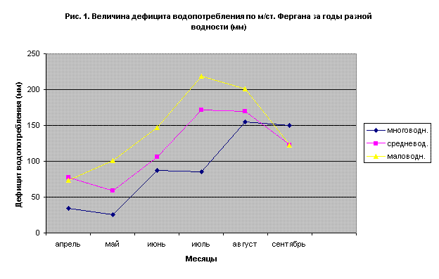
Table shows that foothill zone of the eastern part in the valley has precipitation typical for semi-arid zone, while the most part of valley has dry climate with periodical frosts up to -25oC. Simultaneously essential difference of precipitation between middle, low and high water years is typical on all points of observation from +150 mm to average multiyear in high water years up to -50 mm in low water periods. At figure 1 charts of precipitation fluctuation and evaporation ratio - precipitation for different water periods for two typical meteorological stations - Kokand and Fergana on B.E. Mil'kis. Unfortunately, in water use practice all calculations are carried out on average year, and these deviations, which can cause big changes, are not taken into account in consumption.
On climatic conditions Fergana Valley belongs to Central (Ц-П) cotton zone. West and central parts present desert zone (A) with extremely low precipitation. In east, north- and south-west foothill parts precipitation increases from semi-desert (A1) to ephemeral steppes of light (Б) and typical (B) sierozem and mountain dry steppes - dark (Г) sierozem with prolongation of wet spring phase.
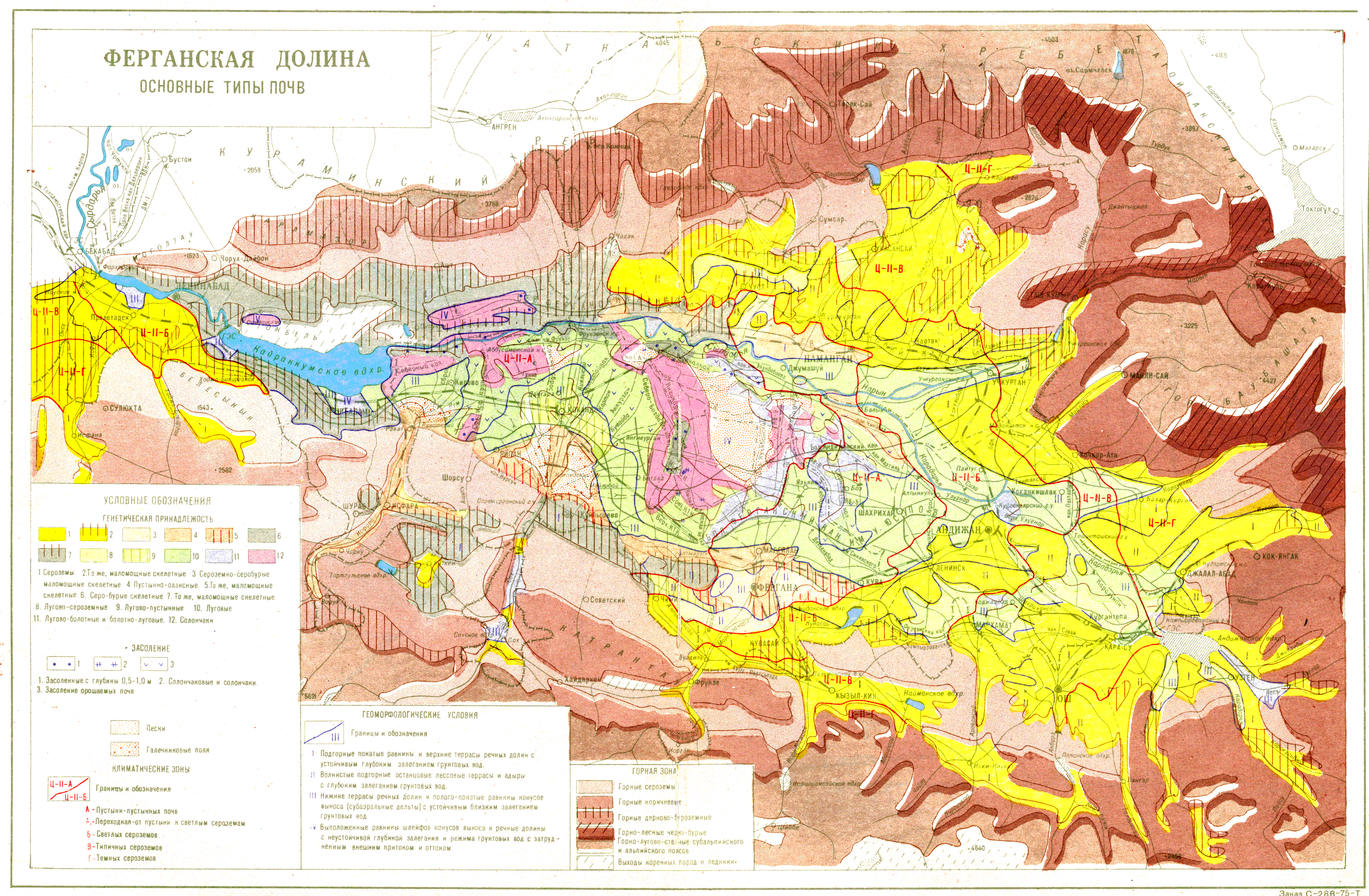
Soils
Valley soil potential formation occurred under influence of Quaternary deposits formation. Repeated change of denudation processes, channel cutting as basis of draining provoked stratified structure of geomorphologic formation, on which top soil was created.
Valley soil types map shows that directly in modern and ancient floodplain basic mass of top soil is consisted from meadow, meadow-swamping, meadow-sierozem soils; solonchak soils correspond to cones of removal; high and foothill valleys as well as upper river terraces are characterized by different types of mountain soils, from mountain sierozem up to mountain-wood black-brown and gravel. Sierozem and sierozem-brown soils occupy enough large area. Special place is taken by sandy-hilly soils of aeolian origin of Central Fergana.